The Hall Farm
Location: The subject farm is located approximately 55 miles west of Chicago O'Hare International Airport. Nearby cities include: Monroe Center (1 1/2 miles north), Rockford (8 miles northwest), and Rochelle (8 5/8 miles southwest).
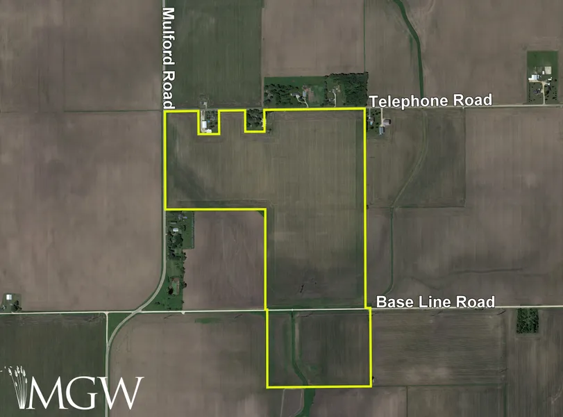
Frontage: There is approximately 3/8 mile of road frontage in Telephone Road, 1/4 mile on Mulford Road, and 1/4 mile on Base Line Road.
Major Highways: Interstate 39/U.S. Route 51 is 1 1/4 miles west, Illinois Route 72 is 2 miles north, and Illinois Route 64 is 3 3/4 miles south of the property.
Legal Description: A brief legal description indicates The Hall Farm is located in Part of the Southwest Quarter of Section 34, Township 42 North Range 2 East (Monroe Township) and Part of the North Half of Section 3, Township 41 North Range 2 East (Lynnville Township), all in Ogle County, Illinois.
Total Acres: There are a total of 148.11 acres, more or less, according to the Ogle County Assessor.
Tillable Acres: There are approximately 142.5 tillable acres, estimated.
Soil Types: Major soil types found on this farm include Plano silt loam, Drummer silty clay loam, and Elburn silt loam.
Topography: The topography of the subject farm is level to nearly level.
Mineral Rights: All mineral rights owned by the seller will be transferred in their entirety to the new owner.
Possession: Possession will be given at closing, subject to the terms and conditions set forth in a purchase contract.
Price Terms: The asking price is $14,750 per acre. A 10% earnest money deposit should accompany any offer to purchase.
Financing: Mortgage financing is available from several sources. Names and addresses will be provided upon request.
Taxes: The 2022 real estate taxes totaled $9,102.26. The tax parcel numbers are: #12-34-300-005, #12-34-300-014 & #19-03-200-001.
Grain Markets: There are a number of grain markets located within 15 miles of The Hall Farm.
Zoning: The property is zoned AG-1, Agricultural.
From elevation to risk assessment
Search for detailed parcel information including; Elevation & Vegetation Maps, Ownership Information, Detailed Parcel Information, Crop History Map, Soil Survey Productivity Data, and more.
Research Parcel InformationDirections
The farm's GPS coordinates are 42.070907, -88.997476, and can be copied and pasted into a mapping application for directions.
Environmental Factors
Resources
Land for Sale by Mark Mommsen
Ogle County Properties By Type
- Farms for Sale in Ogle County, Illinois
- Residential Property for Sale in Ogle County, Illinois
- Ranches for Sale in Ogle County, Illinois
- Undeveloped Land for Sale in Ogle County, Illinois
- Recreational Property for Sale in Ogle County, Illinois
- Timberland for Sale in Ogle County, Illinois
- Horse Property for Sale in Ogle County, Illinois
- Lakefront Property for Sale in Ogle County, Illinois
- Hunting Land for Sale in Ogle County, Illinois
- Commercial Property for Sale in Ogle County, Illinois
- Riverfront Property for Sale in Ogle County, Illinois
- Beachfront Property for Sale in Ogle County, Illinois
Properties for Sale Nearby Counties
Ogle County Properties By City
- Baileyville, Illinois Land for Sale
- Byron, Illinois Land for Sale
- Chana, Illinois Land for Sale
- Creston, Illinois Land for Sale
- Davis Junction, Illinois Land for Sale
- Forreston, Illinois Land for Sale
- Holcomb, Illinois Land for Sale
- Leaf River, Illinois Land for Sale
- Lindenwood, Illinois Land for Sale
- Monroe Center, Illinois Land for Sale
- Mount Morris, Illinois Land for Sale
- Oregon, Illinois Land for Sale
- More
- Polo, Illinois Land for Sale
- Rochelle, Illinois Land for Sale
- Stillman Valley, Illinois Land for Sale
- Woosung, Illinois Land for Sale
- Egan, Illinois Land for Sale
- Flagg, Illinois Land for Sale
- Grand Detour, Illinois Land for Sale
- Haldane, Illinois Land for Sale
- Hillcrest, Illinois Land for Sale
- Honey Creek, Illinois Land for Sale
- Kings, Illinois Land for Sale
- Paynes Point, Illinois Land for Sale
- Stratford, Illinois Land for Sale
- Watertown, Illinois Land for Sale
- Adeline, Illinois Land for Sale
- Briarwood, Illinois Land for Sale
- Childers Acres, Illinois Land for Sale
- Crestwood Acres, Illinois Land for Sale
- Daysville, Illinois Land for Sale
- Eagle Point, Illinois Land for Sale
- Flagg Center, Illinois Land for Sale
- Frahms Country Acres, Illinois Land for Sale
- Harper, Illinois Land for Sale
- Hickory Ridge, Illinois Land for Sale
- Lightsville, Illinois Land for Sale
- Loose Pulley Junction, Illinois Land for Sale
- Lost Nation, Illinois Land for Sale
- Maryland, Illinois Land for Sale
- Myrtle, Illinois Land for Sale
- Ramsey Acres, Illinois Land for Sale
- Southgate, Illinois Land for Sale
- Von Glen Acres, Illinois Land for Sale
- White Rock, Illinois Land for Sale
- Woodland Acres, Illinois Land for Sale