149 Ac CR 239, Rising Star
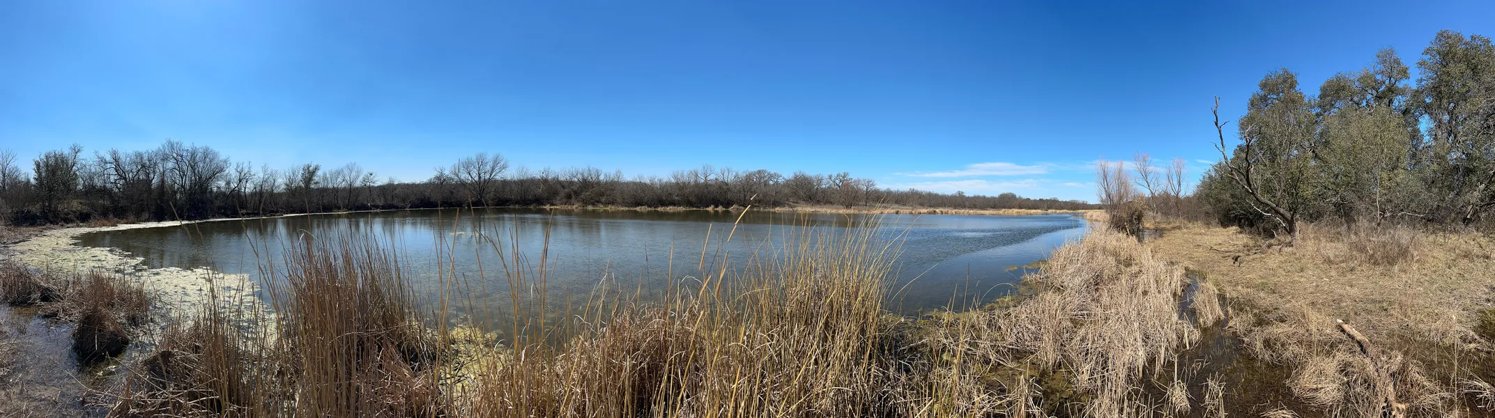
A true hunters paradise! There are 5,375 ft of county road frontage with CR 239 as the western border and CR 255 as the southern border but both sides also have trees sort of blocking the view into the property. There is a gentle elevation change of 30 from the east and west sides of the property down toward the lake. This 3-acre lake in the middle of the property is a hidden gem protected by tree cover all around. The lake is home to an abundance of ducks and a water supply drawing wildlife in. There were deer, turkey and hog tracks in numerous places on the property. There are approx. 50 acres that are very heavily wooded with mostly oak trees and other varieties mixed in. These thick areas are the west side along CR 239 which is so thick you cant drive through most of it. The other heavily wooded areas are along the creek which feeds the lake and around the lake. The remainder of the property is a little over 95 acres of native pasture with scattered open areas and some mesquite flats. There was oil and gas activity in years past but there is no activity now and most of the evidence has been cleaned up. However, the roads are still there which makes access relatively easy. Seller does own some minerals and will convey with acceptable offer.
Westbound SUD has a water line along CR 255 (south side of road) and there is electricity crisscrossing the property. Fences are fair to good in most areas, the water gaps need some improvement and areas where trees have fallen.
This is an amazing place which feels hidden away and you could build a home tucked in the trees to have solace from the outside world.
Estimated Property Taxes for 2025 are $205 with Ag Exemption.
Please contact Hinyard Farm And Ranch Realty to schedule a showing, no trespass-ing. We gladly participate with all cooperating agents and brokers; however, Buyers Agent must accompany Buyer at first showing to participate in full commission split.
At Hinyard Farm And Ranch Realty we try to bring you correct information and the details in this advertisement are understood to be true and reliable, but are not guar-anteed. We do not assume liability for typographical errors, misprints or misinfor-mation that may have been provided to us.
NOTICE OF WATER LEVEL FLUCTUATIONS
The water level of the impoundment of water adjoining the Property fluctuates for various reasons, in-cluding as a result of: (1) an entity lawfully exercising its right to use the water stored in the impound-ment; or (2) drought or flood conditions.
From elevation to risk assessment
Search for detailed parcel information including; Elevation & Vegetation Maps, Ownership Information, Detailed Parcel Information, Crop History Map, Soil Survey Productivity Data, and more.
Research Parcel InformationDirections
From Cross Plains, take Hwy 36 east towards Rising Star approx 6 miles. Turn left (north) onto CR 239 and follow for approximately1.7 miles and property will be on the right (east) side of CR 239. CR 239 is the west boundary and CR 255 is the south boundary.
From Rising Star, take Hwy 36 west towards Cross Plains approx 6 miles. Turn right (north) onto CR 239 and follow for approximately1.7 miles and property will be on the right (east) side of CR 239. CR 239 is the west boundary and CR 255 is the south boundary.
Environmental Factors
Resources
Land for Sale by Shana Hinyard
Eastland County Properties By Type
- Ranches for Sale in Eastland County, Texas
- Hunting Land for Sale in Eastland County, Texas
- Farms for Sale in Eastland County, Texas
- Undeveloped Land for Sale in Eastland County, Texas
- Residential Property for Sale in Eastland County, Texas
- Lakefront Property for Sale in Eastland County, Texas
- Riverfront Property for Sale in Eastland County, Texas
- Horse Property for Sale in Eastland County, Texas
- Recreational Property for Sale in Eastland County, Texas
- Commercial Property for Sale in Eastland County, Texas
- Timberland for Sale in Eastland County, Texas
- Beachfront Property for Sale in Eastland County, Texas
Properties for Sale Nearby Counties
Eastland County Properties By City
- Carbon, Texas Land for Sale
- Cisco, Texas Land for Sale
- Desdemona, Texas Land for Sale
- Eastland, Texas Land for Sale
- Gorman, Texas Land for Sale
- Olden, Texas Land for Sale
- Ranger, Texas Land for Sale
- Rising Star, Texas Land for Sale
- Branton, Texas Land for Sale
- Chaney, Texas Land for Sale
- Chuckville, Texas Land for Sale
- Kokomo, Texas Land for Sale
- More
- Mangum, Texas Land for Sale
- Mitchell, Texas Land for Sale
- Morton Valley, Texas Land for Sale
- Mountain Top, Texas Land for Sale
- Okra, Texas Land for Sale
- Pioneer, Texas Land for Sale
- Romney, Texas Land for Sale
- Sabanno, Texas Land for Sale
- Scranton, Texas Land for Sale
- Staff, Texas Land for Sale
- Tiffin, Texas Land for Sale
- Union Center, Texas Land for Sale