Guide Rock Farms
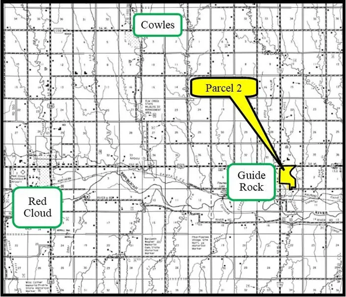
Location: Parcel 2 is located on the east side of Highway 78 right outside of Guide Rock, NE to the north.
Legal Desc: Parcel 2: NW1/4 & N1/2 SW1/4 Less a 29.98-acre tract and Lot 11 less tract, all of Section 3-T1N-R9W of the 6th P.M., Webster County, Nebraska.
Acres: Webster County Assessor indicates an estimated total of 212.00 taxed assessed acres for Parcel 2.
Land Use: Parcel 2: Dry cropland and pasture/rangeland with Certified Irrigated Acres.
Soils: Parcel 2 cropland soils consist of Class II, III, VI, Hord, Holdrege, or Hobbs silt loams, Geary and Hobbs soils. Parcel 2 rangeland soils consist of Class II-VI Geary and Hobbs, Hobbs, and Holdrege soils.
Taxes: 2021 Real Estate taxes payable in 2022: Parcel 2: estimated $6,726.
Irrigation Well Registration Parcel 2: G-006797
Information: Parcel 2: Has a well that is registered at 350 gpm and has not been utilized in recent years, but does contain CIAs.
FSA Info: The following information is the total of both Parcel 1 & Parcel 2: Cropland 378.19 acres with Wheat 44.9 acres at PLC yield of 38; Corn - 94.5 acres at PLC yield of 139; Grain Sorghum24.9 acres at PLC yield of 63; and Soybeans - 150.5 acres at PLC yield of 35.
Comments: Parcel 2 is a great combination of dry cropland and pasture as well as Certified Irrigated
Acres. (Parcel 2 does not include the Quonset site in the northwest corner.)
List Price: Parcel 2 - $875,000
From elevation to risk assessment
Search for detailed parcel information including; Elevation & Vegetation Maps, Ownership Information, Detailed Parcel Information, Crop History Map, Soil Survey Productivity Data, and more.
Research Parcel InformationResources
Land for Sale by Agri Affiliates | Kearney
Webster County Properties By Type
- Farms for Sale in Webster County, Nebraska
- Ranches for Sale in Webster County, Nebraska
- Commercial Property for Sale in Webster County, Nebraska
- Riverfront Property for Sale in Webster County, Nebraska
- Hunting Land for Sale in Webster County, Nebraska
- Recreational Property for Sale in Webster County, Nebraska
- Undeveloped Land for Sale in Webster County, Nebraska
- Residential Property for Sale in Webster County, Nebraska
- Horse Property for Sale in Webster County, Nebraska
- Lakefront Property for Sale in Webster County, Nebraska
- Beachfront Property for Sale in Webster County, Nebraska
- Timberland for Sale in Webster County, Nebraska
Properties for Sale Nearby Counties
Webster County Properties By City
- Bladen, Nebraska Land for Sale
- Blue Hill, Nebraska Land for Sale
- Guide Rock, Nebraska Land for Sale
- Inavale, Nebraska Land for Sale
- Red Cloud, Nebraska Land for Sale
- Cowles, Nebraska Land for Sale
- Rosemont, Nebraska Land for Sale
- Amboy, Nebraska Land for Sale
- Lester Junction, Nebraska Land for Sale
- Pawnee Village, Nebraska Land for Sale