East Fork Boulder Creek Timber Tract
SIZE: 296 Acres
ELEVATION: 4,800 to 5,700 Feet
ZONING: TPZ (Timber Production Zone)
RESERVE PRICE: $165,000
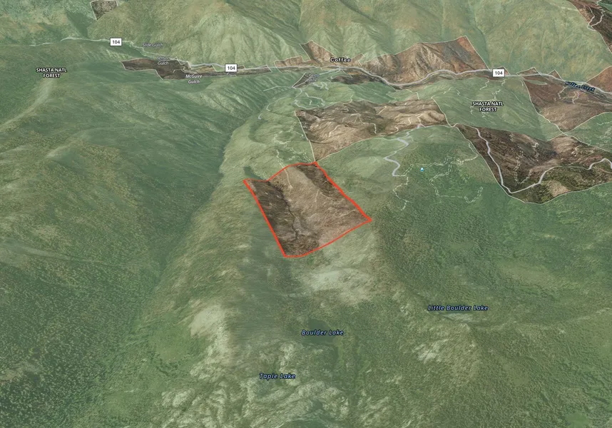
The 296 acre East Fork Boulder Creek timber and recreation tract is located within the Shasta-Trinity National Forest, along the eastern boundary of the Trinity Alps Wilderness less than one mile north of Boulder Lake, is one of the most popular hiking destinations in the Trinity Alps Wilderness. East Fork Boulder Creek runs through the property from its source at Boulder Lake.
The entire 296 acres was impacted by the 2021 River Complex Fire that burned as a crown fire, with few trees surviving. Seller has not undertaken any salvage logging. A CFIP California Grant for Reforestation was approved but is not transferable. A new owner would need to submit an application if additional funding is available. Please see Supplemental Information Package for detail.
There is physical access from State Route 104 by Goldfield Campground, two miles north of the property (USFS Road 37N42Y).
The topography is primarily moderate to steep east and west-facing slopes along the East Boulder Creek drainage. There are dirt logging roads northwest and east of the creek, which has an estimated 52 acres of riparian area with some residual trees not impacted by the fire. The trail to Boulder Lake is located near the southeast corner.
The tract is classified as timberland, with annual taxes of less than $30 per year. Acquisition of the 296 acres could provide opportunity to have a base camp by Trinity Alps Wilderness at a price of less than $560 per acre.
Property is offered in July 10, 2024 Sealed Bid Auction.
From elevation to risk assessment
Search for detailed parcel information including; Elevation & Vegetation Maps, Ownership Information, Detailed Parcel Information, Crop History Map, Soil Survey Productivity Data, and more.
Research Parcel InformationDirections
Township 37 North, Range 8 West, East of Section 17, Account No. 004-300-002, Trinity County, California
Resources
Land for Sale by Colleen Cowan
Trinity County Properties By Type
- Undeveloped Land for Sale in Trinity County, California
- Residential Property for Sale in Trinity County, California
- Riverfront Property for Sale in Trinity County, California
- Ranches for Sale in Trinity County, California
- Farms for Sale in Trinity County, California
- Lakefront Property for Sale in Trinity County, California
- Recreational Property for Sale in Trinity County, California
- Hunting Land for Sale in Trinity County, California
- Timberland for Sale in Trinity County, California
- Horse Property for Sale in Trinity County, California
- Commercial Property for Sale in Trinity County, California
- Beachfront Property for Sale in Trinity County, California
Properties for Sale Nearby Counties
Trinity County Properties By City
- Big Bar, California Land for Sale
- Burnt Ranch, California Land for Sale
- Douglas City, California Land for Sale
- Hayfork, California Land for Sale
- Hyampom, California Land for Sale
- Junction City, California Land for Sale
- Lewiston, California Land for Sale
- Mad River, California Land for Sale
- Salyer, California Land for Sale
- Trinity Center, California Land for Sale
- Weaverville, California Land for Sale
- Zenia, California Land for Sale
- More
- Helena, California Land for Sale
- Peanut, California Land for Sale
- Bob Hoaglin Place, California Land for Sale
- Bramlet Place, California Land for Sale
- Bucktail, California Land for Sale
- Carrville, California Land for Sale
- Cedar Stock, California Land for Sale
- Coffee, California Land for Sale
- Coffee Creek, California Land for Sale
- Crabtree Place, California Land for Sale
- Deadwood, California Land for Sale
- Dedrick, California Land for Sale
- Del Loma, California Land for Sale
- Denny, California Land for Sale
- Estrellita, California Land for Sale
- Forest Glen, California Land for Sale
- Friend Place, California Land for Sale
- Globe Mill, California Land for Sale
- Graham Place, California Land for Sale
- Hawkins Bar, California Land for Sale
- Hoboken, California Land for Sale
- Island Mountain, California Land for Sale
- Kekawaka, California Land for Sale
- Kettenpom, California Land for Sale
- Luckie Place, California Land for Sale
- McClellan Place, California Land for Sale
- Miller Place, California Land for Sale
- Murphy Place, California Land for Sale
- Nielson Place, California Land for Sale
- Payne, California Land for Sale
- Penney, California Land for Sale
- Pinewood Cove, California Land for Sale
- Ridgeville, California Land for Sale
- Russ Place, California Land for Sale
- Shannon Place, California Land for Sale
- Sids Place, California Land for Sale
- Trinity Alps, California Land for Sale
- Trinity Village, California Land for Sale
- Ueland Place, California Land for Sale
- Wigdon Place, California Land for Sale
- Willie Hoaglin Place, California Land for Sale
- Yellowjacket Place, California Land for Sale