Timberon 2 Adjoining Lots - Over One Full Acre
Two lots totaling just over one full acre located in the community of Timberon, New Mexico, in the Sacramento Mountains in the southern part of the Lincoln National Forest. Great views from these lots. You can use them as a location for a permanent home or a vacation getaway.
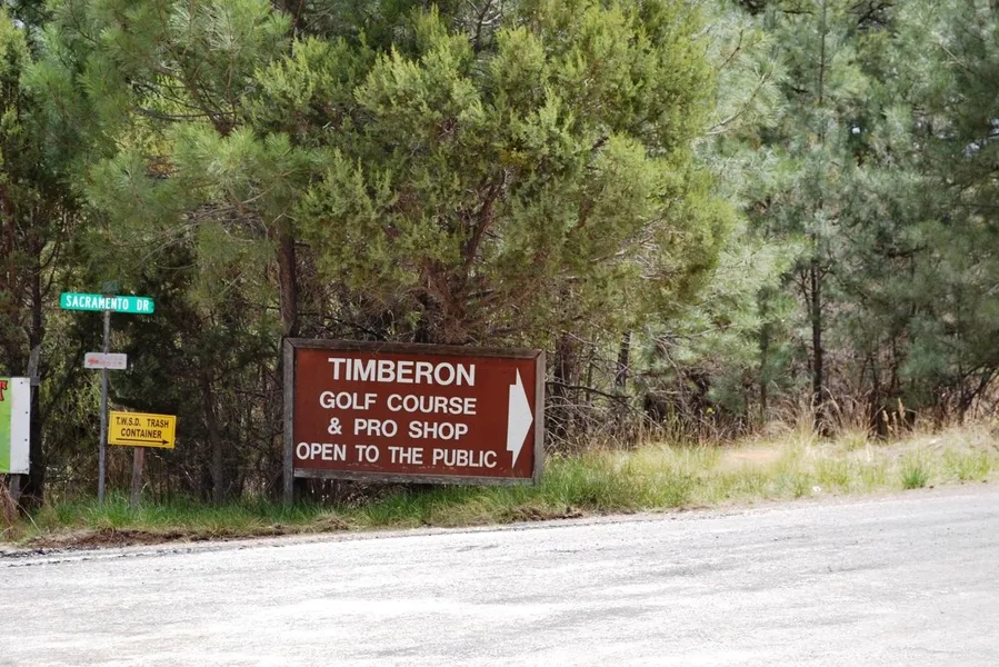
Timberon
Located in Otero County in south central New Mexico, Timberon is south of Cloudcroft and southeast of Alamogordo. The elevation ranges from 6,900 to 7,200 feet within the community. This mountain paradise includes an airport for the aviation enthusiasts. For the golf fans there is a 9-hole regulation golf course with a clubhouse and restaurant. The community pool is maintained by the local water district and is normally open from Memorial day to Labor day.
For the outdoor enthusiast Timberon has a fishing lake and miles of trails and primitive roads for your off-road vehicle adventures. When you are done stop by one of the three community restaurants for a bite to eat. Other services in the area include a hardware and general store for supplies and groceries, and a volunteer fire department with EMS and ambulance service.
Land Info (adjoining lots, see plat map):
Size: 1.01 Acres Total
APN: R044344 & R044345
Legal: Timberon Unit 12 Block 115 Lot 2 & 18 (adjoining lots, see plat map)
Lot 2:
Size: .502 Acres
APN: R044344
Legal: Timberon Unit 12 Block 115 Lot 2
Dimensions: Approximately 106' X 206' X 121' X 160'
Address: Fuerte Drive
GPS: Approximate GPS Coordinates Lot
32.629305, -105.664881 (NW Corner)
32.629546, -105.664258 (NE Corner)
32.629223, -105.664135 (SE Corner)
32.629084, -105.664684 (SW Corner)
Lot 18:
Size: .511 Acres
APN: R044345
Legal: Timberon Unit 12 Block 115 Lot 18
Dimensions: Approximately 104' X 262' X 100' X 175'
Address: Fuerte Drive
GPS: Approximate GPS Coordinates Lot
32.629852, -105.664995 (NW Corner)
32.630151, -105.664658 (NE Corner)
32.629546, -105.664258 (SE Corner)
32.629484, -105.664583 (SW Corner)
Plat map, and larger high resolution pictures available - please inquire.
Owner financing available, please inquire. No credit checks, everyone qualifies. We accept all major credit cards. All cash offers considered.
Document preparation fee: $199
C-2018030-OTT
From elevation to risk assessment
Search for detailed parcel information including; Elevation & Vegetation Maps, Ownership Information, Detailed Parcel Information, Crop History Map, Soil Survey Productivity Data, and more.
Research Parcel InformationBoise, ID
Land for Sale by Government Land Sales
Otero County Properties By Type
- Undeveloped Land for Sale in Otero County, New Mexico
- Ranches for Sale in Otero County, New Mexico
- Residential Property for Sale in Otero County, New Mexico
- Hunting Land for Sale in Otero County, New Mexico
- Recreational Property for Sale in Otero County, New Mexico
- Farms for Sale in Otero County, New Mexico
- Commercial Property for Sale in Otero County, New Mexico
- Riverfront Property for Sale in Otero County, New Mexico
- Horse Property for Sale in Otero County, New Mexico
- Timberland for Sale in Otero County, New Mexico
- Lakefront Property for Sale in Otero County, New Mexico
- Beachfront Property for Sale in Otero County, New Mexico
Properties for Sale Nearby Counties
- Chaves County, New Mexico Land for Sale
- Culberson County, New Mexico Land for Sale
- Dona Ana County, New Mexico Land for Sale
- Eddy County, New Mexico Land for Sale
- El Paso County, New Mexico Land for Sale
- Hudspeth County, New Mexico Land for Sale
- Lincoln County, New Mexico Land for Sale
- Sierra County, New Mexico Land for Sale
Otero County Properties By City
- Alamogordo, New Mexico Land for Sale
- Bent, New Mexico Land for Sale
- Cloudcroft, New Mexico Land for Sale
- La Luz, New Mexico Land for Sale
- Mayhill, New Mexico Land for Sale
- Mescalero, New Mexico Land for Sale
- Orogrande, New Mexico Land for Sale
- Sacramento, New Mexico Land for Sale
- Timberon, New Mexico Land for Sale
- Tularosa, New Mexico Land for Sale
- Weed, New Mexico Land for Sale
- Three Rivers, New Mexico Land for Sale
- More
- Alamorosa, New Mexico Land for Sale
- Alvarado, New Mexico Land for Sale
- Apache, New Mexico Land for Sale
- Avis, New Mexico Land for Sale
- Blazers Mill, New Mexico Land for Sale
- Boles Acres, New Mexico Land for Sale
- Carrizo, New Mexico Land for Sale
- Chippeway Park, New Mexico Land for Sale
- Corner Well, New Mexico Land for Sale
- Crisp, New Mexico Land for Sale
- Dunes, New Mexico Land for Sale
- Elwood, New Mexico Land for Sale
- High Rolls, New Mexico Land for Sale
- Hortonville, New Mexico Land for Sale
- Kearney, New Mexico Land for Sale
- Marcia, New Mexico Land for Sale
- Maxon, New Mexico Land for Sale
- Mountain Park, New Mexico Land for Sale
- Newman, New Mexico Land for Sale
- Old Wright Place, New Mexico Land for Sale
- Omlee, New Mexico Land for Sale
- Piñon, New Mexico Land for Sale
- Point of Sands, New Mexico Land for Sale
- Salinas, New Mexico Land for Sale
- Silver Springs, New Mexico Land for Sale
- Turquoise, New Mexico Land for Sale
- Valmont, New Mexico Land for Sale
- Whitetail, New Mexico Land for Sale
- Wimsatt, New Mexico Land for Sale