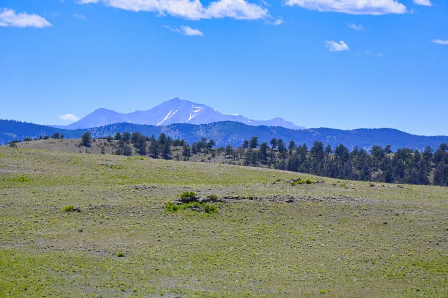
Breathtaking Mountain Views in the Peace & Quiet!
Escape to the breathtaking beauty of nature with this stunning 5 acre parcel of land located 14 miles south of Hartsel. Enjoy panoramic views of snow capped mountains and rolling green hills stretching for miles from the elevated plateau in the center of the property. The majority of the land opens up to the west, where the best views can be found near the highest point not far off the road. Perfect for outdoor enthusiasts, this land is ideal for recreational activities such as camping, hunting, or building an off-grid cabin. With very few people around you can create your own peaceful mountain retreat and immerse yourself in the great outdoors!
Owner financing available on all properties and everyone qualifies. We also include a 15% prepayment discount if you want to pay off early and save! Contact us or check out our site for more information on available options.
SUBDIVISION: ESTATES OF COLORADO
ADDRESS: SENECA RD, HARTSEL, CO 80449
SIZE: 5 acres
APN: 45061
LEGAL DESCRIPTION: Lot 3050, Estates of Colorado, Unit 59, as shown on the plat of said subdivision recorded October 5, 1970 at Reception No. 182605, County of Park, State of Colorado.
APPROX. GPS COORDINATES:
NW: 38.853878, -105.759819
NE: 38.853788, -105.757050
SE: 38.853015, -105.757397
SW: 38.853002, -105.759910
APPROX. ELEVATION: 9,471 ft
ZONING: Residential
CAMPING & RVs: Both RV and Tent Short Term
IMPROVEMENTS: None
ANNUAL TAXES: Approx. $190
HOA/POA FEES: None
SEWER: Would need septic system if building.
WATER: Would be by well, holding tank or other similar option.
UTILITIES: Solar or generator best options for electricity. Gas by propane tank. Phone by cellular.
ACCESS: County dirt road. Accessible by car weather permitting or with four-wheel drive vehicle in inclement weather.
From elevation to risk assessment
Search for detailed parcel information including; Elevation & Vegetation Maps, Ownership Information, Detailed Parcel Information, Crop History Map, Soil Survey Productivity Data, and more.
Research Parcel InformationDirections
Please use this google maps link for the best driving directions to the property: https://maps.app.goo.gl/48WmBsR8oeA89bzt9
Environmental Factors
Resources
Land for Sale by Adam Wilkerson
Park County Properties By Type
- Undeveloped Land for Sale in Park County, Colorado
- Ranches for Sale in Park County, Colorado
- Residential Property for Sale in Park County, Colorado
- Riverfront Property for Sale in Park County, Colorado
- Lakefront Property for Sale in Park County, Colorado
- Beachfront Property for Sale in Park County, Colorado
- Hunting Land for Sale in Park County, Colorado
- Farms for Sale in Park County, Colorado
- Horse Property for Sale in Park County, Colorado
- Recreational Property for Sale in Park County, Colorado
- Timberland for Sale in Park County, Colorado
- Commercial Property for Sale in Park County, Colorado
Properties for Sale Nearby Counties
Park County Properties By City
- Alma, Colorado Land for Sale
- Bailey, Colorado Land for Sale
- Como, Colorado Land for Sale
- Fairplay, Colorado Land for Sale
- Grant, Colorado Land for Sale
- Guffey, Colorado Land for Sale
- Hartsel, Colorado Land for Sale
- Jefferson, Colorado Land for Sale
- Lake George, Colorado Land for Sale
- Shawnee, Colorado Land for Sale
- Tarryall, Colorado Land for Sale
- Alma Junction, Colorado Land for Sale
- More
- Antero Junction, Colorado Land for Sale
- Balfour, Colorado Land for Sale
- Bordenville, Colorado Land for Sale
- Estabrook, Colorado Land for Sale
- Garo, Colorado Land for Sale
- Glenisle, Colorado Land for Sale
- Glentivar, Colorado Land for Sale
- Haver, Colorado Land for Sale
- Insmont, Colorado Land for Sale
- Peabodys, Colorado Land for Sale
- Pike-San Isabel Village, Colorado Land for Sale
- Platte Springs, Colorado Land for Sale
- Santa Maria, Colorado Land for Sale
- Singleton, Colorado Land for Sale
- Trump, Colorado Land for Sale
- Webster, Colorado Land for Sale
- Weller, Colorado Land for Sale
- Will-O-The-Wisp, Colorado Land for Sale